We had more or less figured out our route through Canada: we wanted to see the National Parks of Banff and Jasper and then continue to Edmonton to pay some more of my relatives a visit. We were also always on the lookout for nice multi-day hikes and thus we stumbled upon a whole different area we had never heard about: the Purcell Wilderness Conservancy Provincial Park. The Purcell wilderness lies some distance west of Banff National Park and derives it’s name from the Purcell mountain range that runs between the eastern and western parts of the Kootenays (another bigger mountain range).
Before we went there we did our second family visit though and met Rita and her husband Kevin. Rita is a sister of Alfred, so she’s a half-cousin of mine too. She lives in Kamloops which is kind of a desert town lying at the Trans-Canada-Highway. Alfred had given me her phone number in case we should pass though Kamloops which we ended up doing. We even spent three days there since it was also the biggest city along our route from Vancouver to the Purcell wilderness area. When I gave Rita a call I was of course quite excited and I was relieved when I realized that Alfred had already given her a warning that we might stop by. She sounded very nice on the phone and it was also very uncomplicated to meet up with her: some three hours after our call Martin and I were already sitting in her living room. Apparently she and her husband loved to be in the sun so they spent the summer in Kamloops and the last winter in Arizona where we had begun the USA leg of our journey. We had also noticed that the climate and landscape around Kamloops and Phoenix seemed to be a bit similar to each other. We stayed about three hours at Rita’s and Kevin’s place while telling them stories from our journey, as well as hearing theirs since they also travel a lot with their trailer. When we said our goodbyes we were happy that we had decided to pay Rita and Kevin a visit. We wish them a lot more fantastic travels in their trailer!
The city of Kamloops itself wasn’t that attractive to us since it seemed to consist of some cluster of shopping areas and fast food chains like we had seen it in many american cities before. We liked the very hot weather there though. Much to our surprise we found a really pretty spot to camp a few miles outside of town – the Greenstone Mountain Provincial Park. It’s main purpose is to serve as playground for ATV drivers but it’s so big that you can find nice places everywhere where you’ll be left pretty much alone. There were scores of squirrels running around in the woods and just when we had arrived there we saw a wolf! It was around the late afternoon and he showed us his profile while strolling up a hill about 200 yards away from us. There were some ATV trails around the place we chose for our camper but luckily nobody came by. From time to time we’d hear some engine noise from afar but for a free campsite Greenstone proved to be delightingly remote and quiet.
We spent two nights in the woods and during the days we did some shopping for our upcoming multi-day wilderness hike. In addition to that we wanted to have our car checked thoroughly and we were happy that everything turned out to be perfectly fine with it.
Along the way to Purcell we made another stop in a town named Revelstoke and we were quite surprised to find it chock-full of tourists who were bustling around everywhere! There were rows of RVs and similar vehicles and we saw everything from small VW vans (Canadians seemed to especially like the Westfalia model) to ridiculously humongous trailers pulled by almost semi trucks (which was sort of overkill but gas is very cheap even in Canada). Nevertheless – Revelstoke is a nice little town and we purchased pone of our favourite pieces of hiking equipment there: the LifeStraw. That is a very handy water filter that enables you to drink directly from a microbiotically contaminated water source by just using it as a drinking straw. We had heard about it for the first time when we had been to the Bill & Melinda Gates Foundation in Seattle since they had sponsored the development of this device (it’s main purpose is to provide a source of clean water for people that have no access to potable water or live in an area where a natural disaster has occurred). It cost around 30 bucks and we deemed this to be a small price to pay for not having to schlep several litres of water around with us by allowing us to drink directly from a stream instead (bad enough that you need a filter for that nowadays even in protected areas but in North America there’s intestinal parasites causing “bear fever” in most bodies of water).
From Revelstoke we drove south to the ferry we needed to take in order to get to the western edge of the Purcell wilderness area where our hiking destination – the Earl Grey Pass Trail – lay. That trail is some 61 kilometers long and leads you right across the Purcell wilderness area. It got it’s name from the actual Earl Grey, the guy with the tea who had been Canada’s governor general at the beginning of the 20th century. He had hiked along an old miner’s trail there and found the area very much to his liking. We didn’t intend to hike the whole distance since it’s not a round trip and we would have had a nearly unsolvable problem to get back to our camper from the east end of the trail (it’s a drive of more than 400 kilometers). We just packed provisions for five days and wanted to see how far we got until we would have to turn around.
It takes an effort to even get to the west end of the Earl Grey Pass Trail. At first you have to drive some 50 kilometers through an uninhabited area to get form Revelstoke to the ferry across Upper Arrow Lake. The 20-minute ferry crossing doesn’t cost anything even with the ferry operating all day long. After that it’s a drive of nearly 100 kilometers on a gravel road that winds through an equally uninhabited and beautiful stretch of Canada until you reach the tiny hamlet of Argenta. Our map said that Argenta would be a small village but actually it’s just a loose string of some few wooden houses and one community center aka post office. You just live in a place like that if you really want to live like that. It’s probably not a lot of fun during winter but in summer it’s a dream come true!
Map: Zoom out to see the remote area around our destination.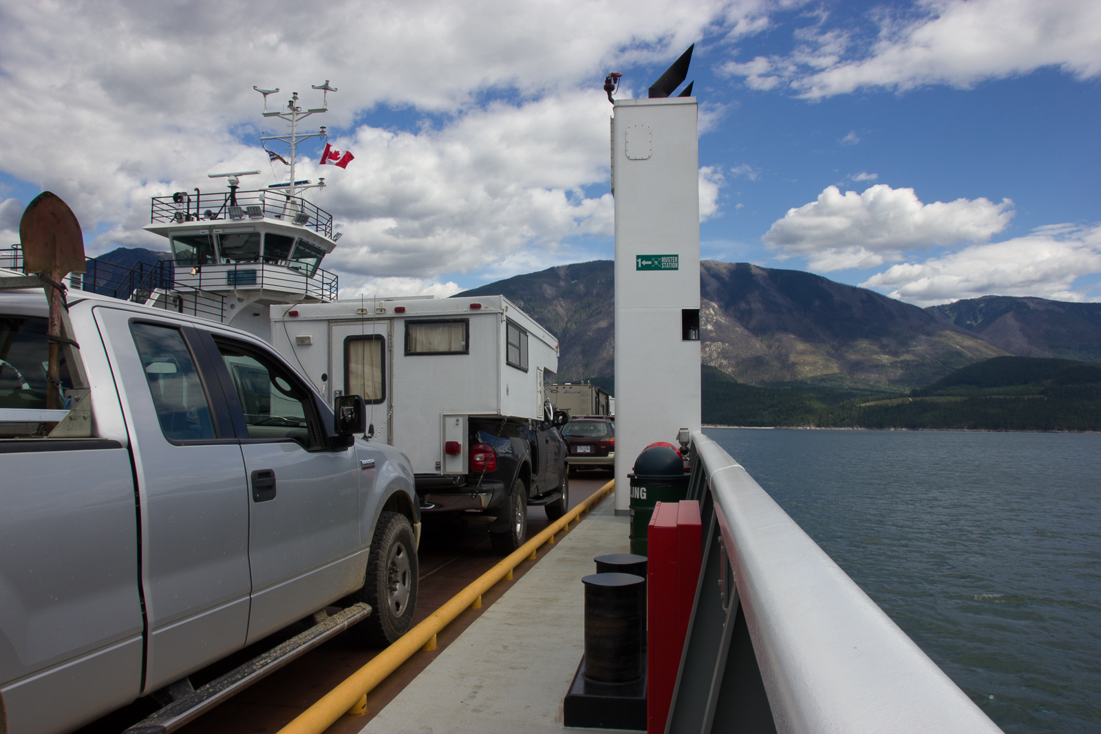
Shortly after we had finally arrived at the Earl Grey Pass trail head after some three hours of driving we passed a weird-looking, slightly creepy graveyard of broken old cars that had been left at the side of the road. Some were standing there with open doors and missing parts and looked as if some crazed hillbilly had just dragged the last tourists from their wrecked car. The handpainted sign saying “sunshine” above that mess didn’t help to lighten the mood either.
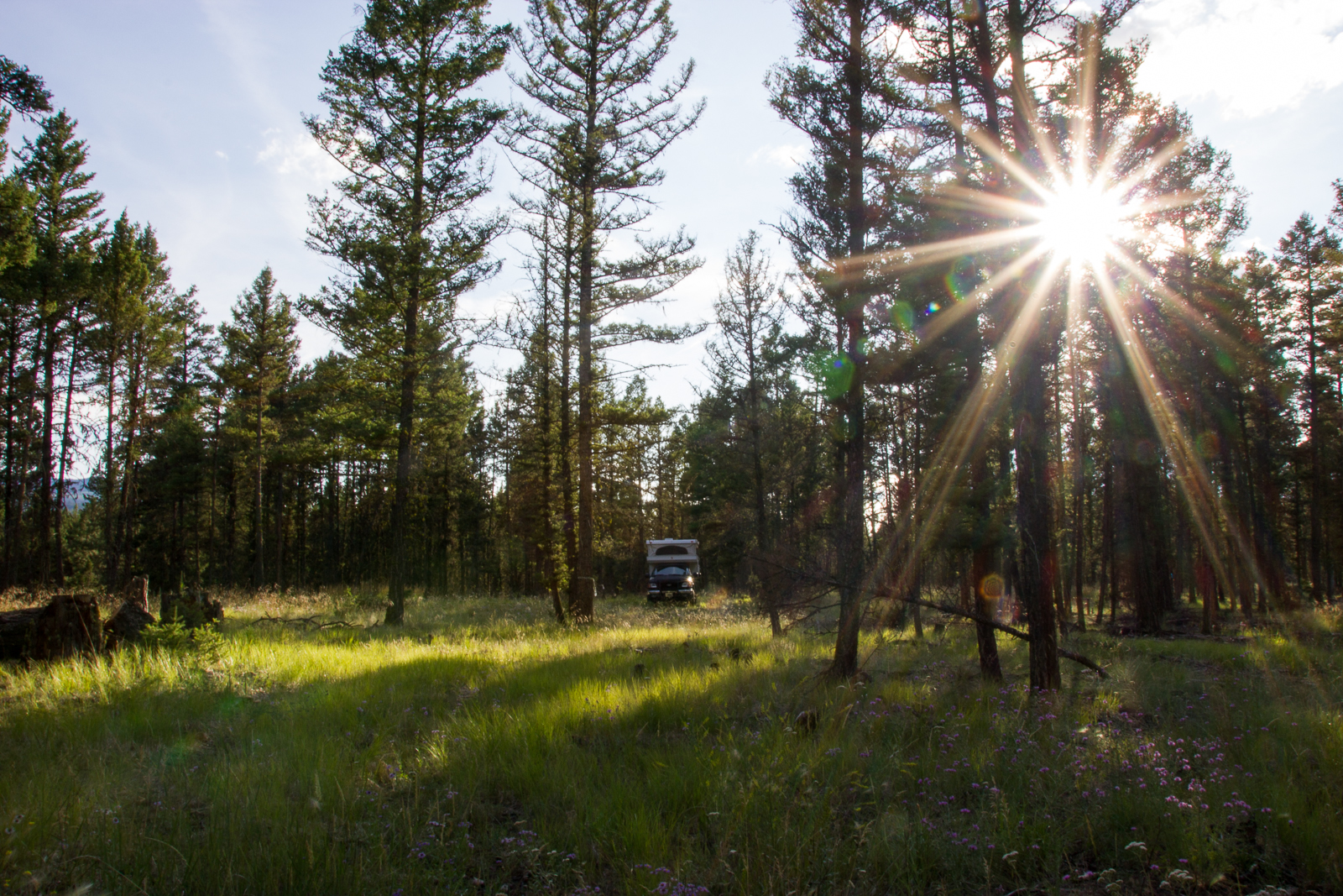
Directly behinde the roadside junkyard we found a place for our camper and parked there for the night to start our hike early the next day. At the time we had gathered everything on our equipment list and fitted it into our backpacks the next day it was already around noon and we realized that we had taken way too long for that. We walked to the trailhead and signed the guestbook there where we also learned that somebody was on the trail. A father and son duo had started earlier that day and we met them three days later on the way back.
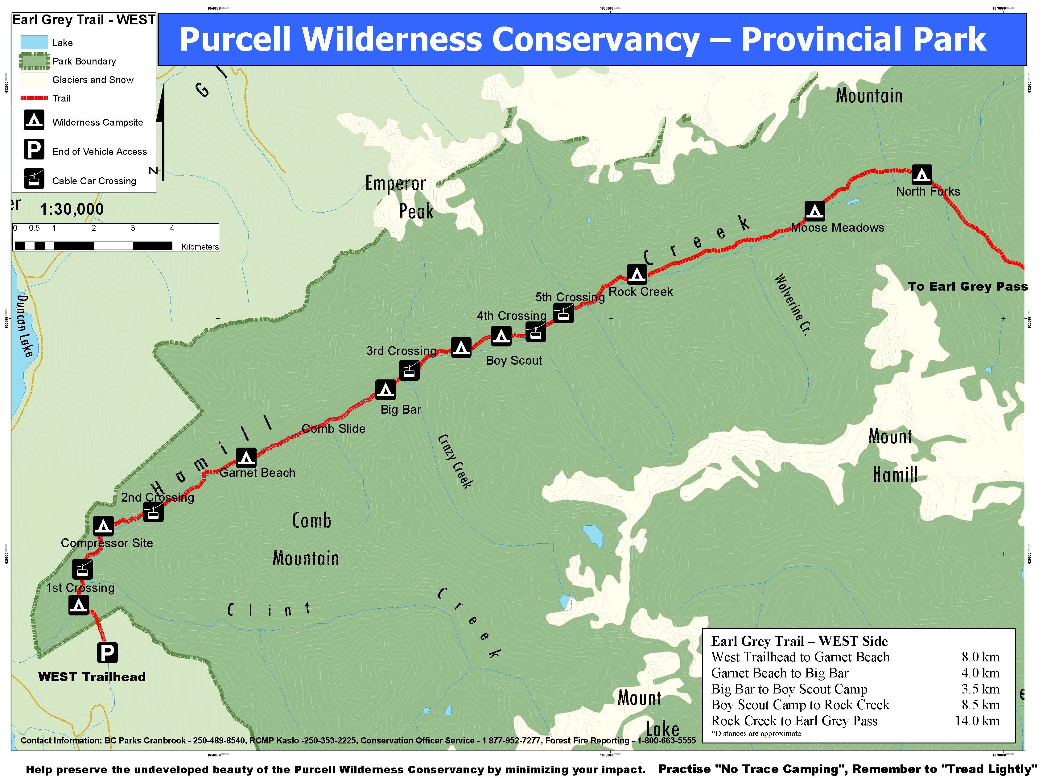
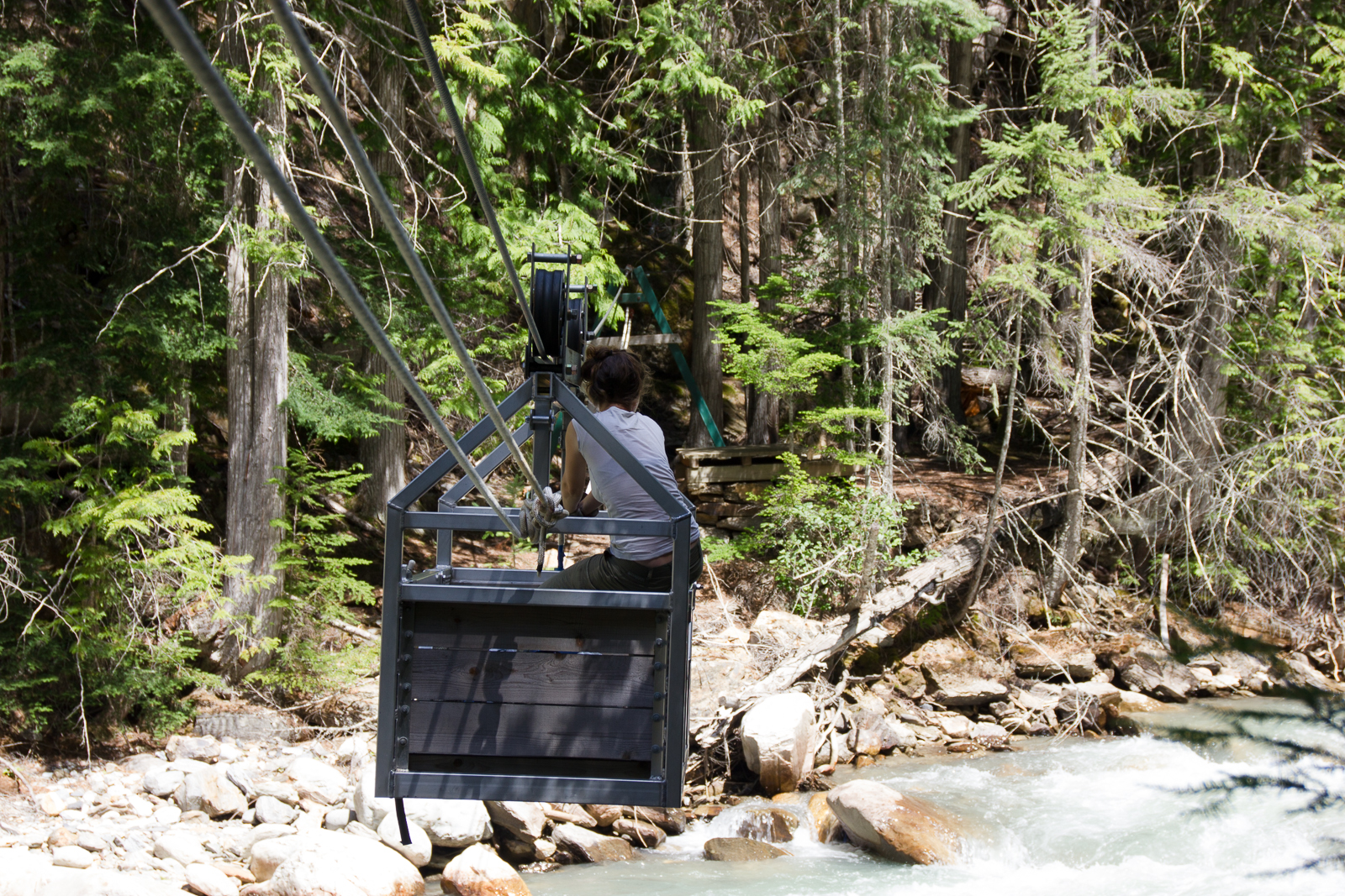
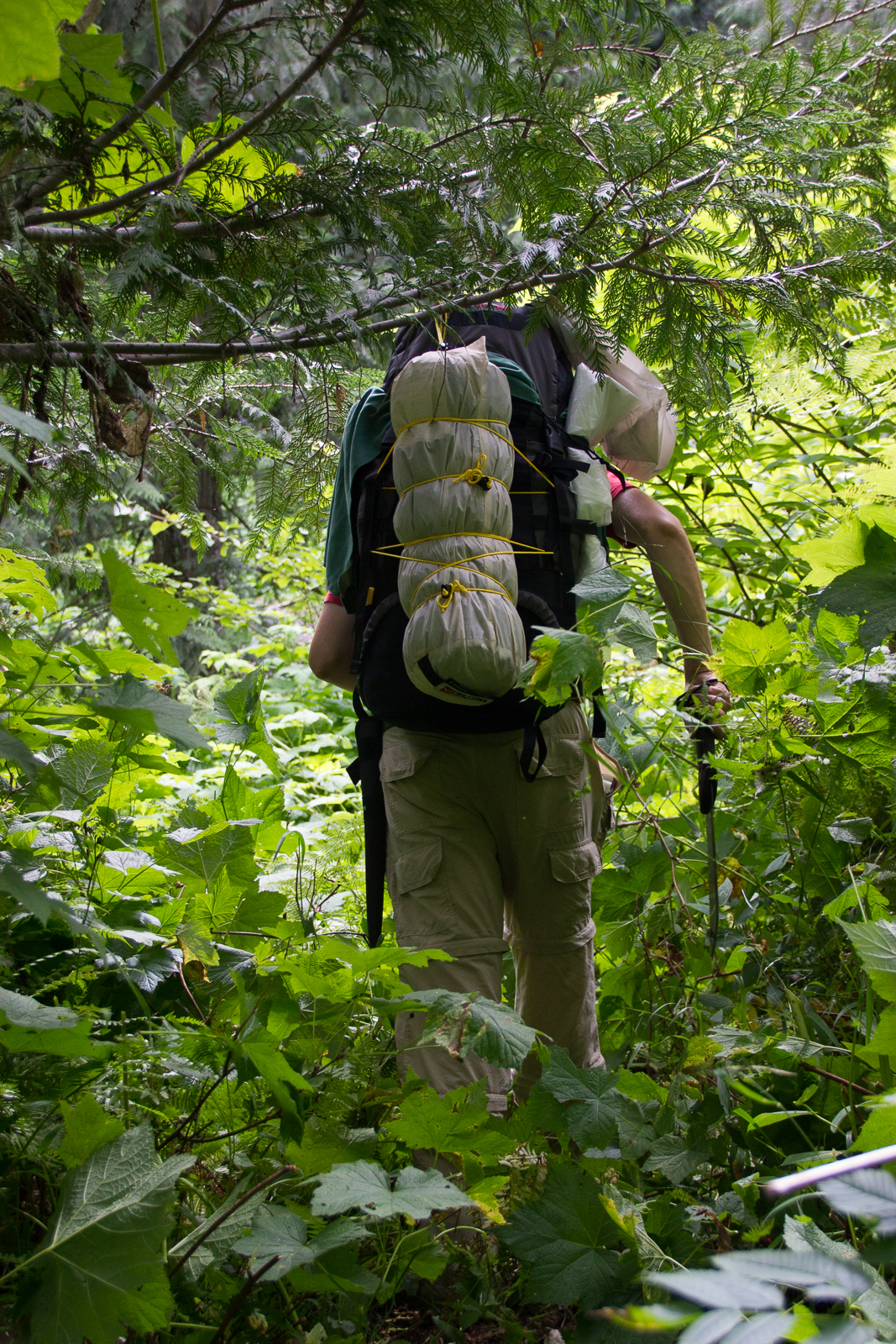
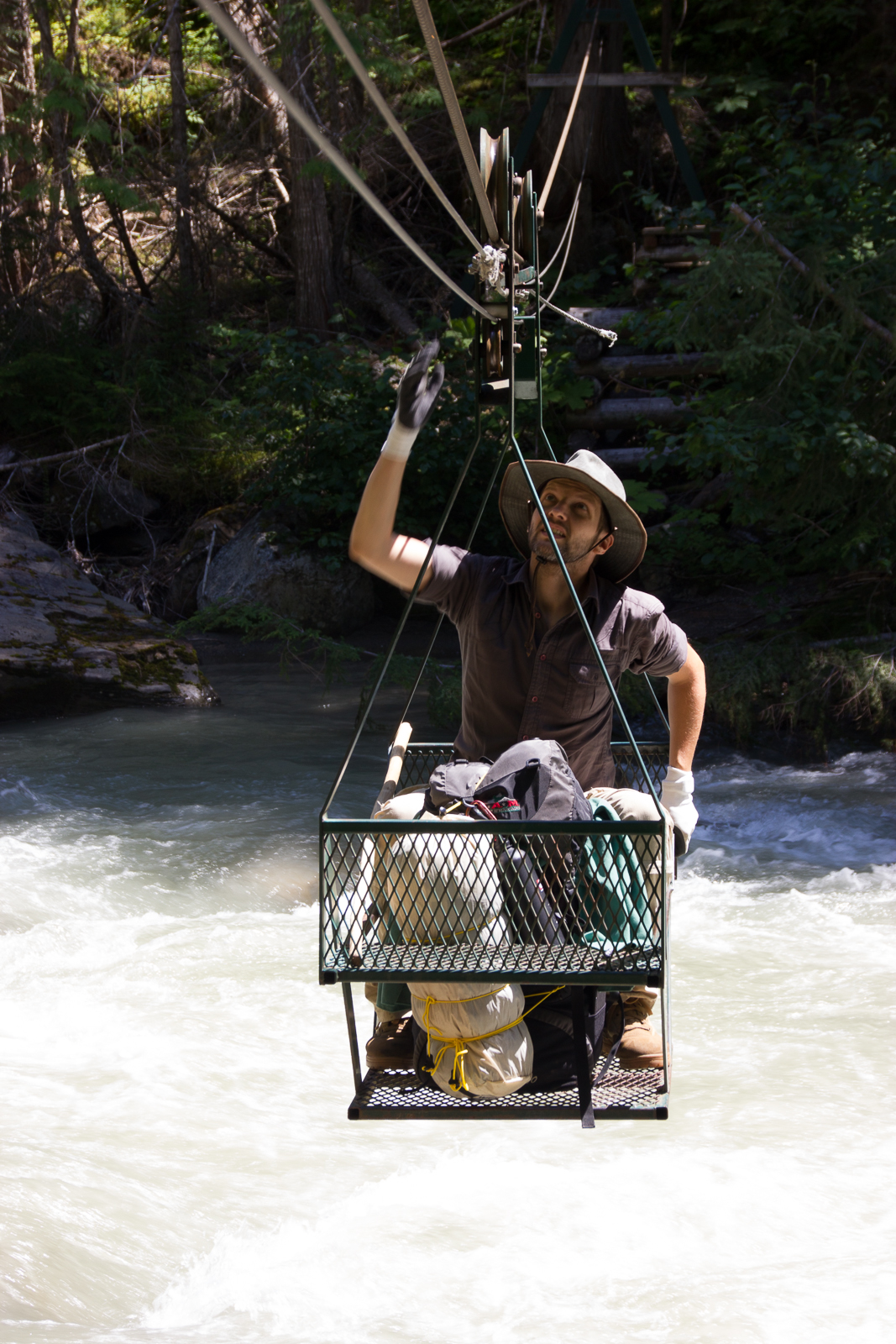
There’s not too much information to be found on the internet about the Earl Grey Pass Trail, so we thought it might be a good idea to show some details in this article that might be useful for other hikers. We need to mention right away that we had hoped to maybe make it as far as the Earl Grey Pass but we realized very soon that we wouldn’t be able to reach this goal. Most of the time we only averaged about 1 km per hour and we just got as far as the third cable car before we turned around which amounts to roughly 26 km all in all. The reason for us going so slow is the very nature of the wilderness trail. There are a lot of blown down trees blocking the trail so you have climb over them and there are also stretches of dense brush we had to bushwhack through with a machete. The cable cars that you have to use at some places to be able to cross the churning river are hard to operate too. Martin was pretty much ok but I had quite some difficulty hauling the things across the river.

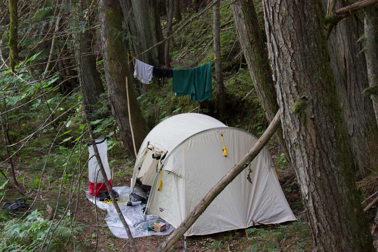
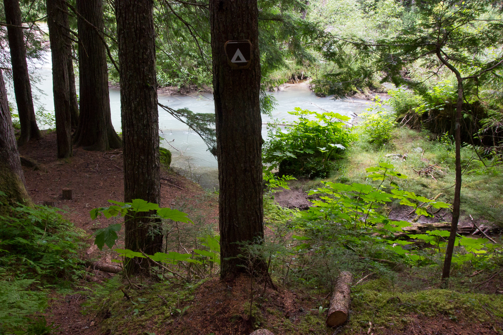
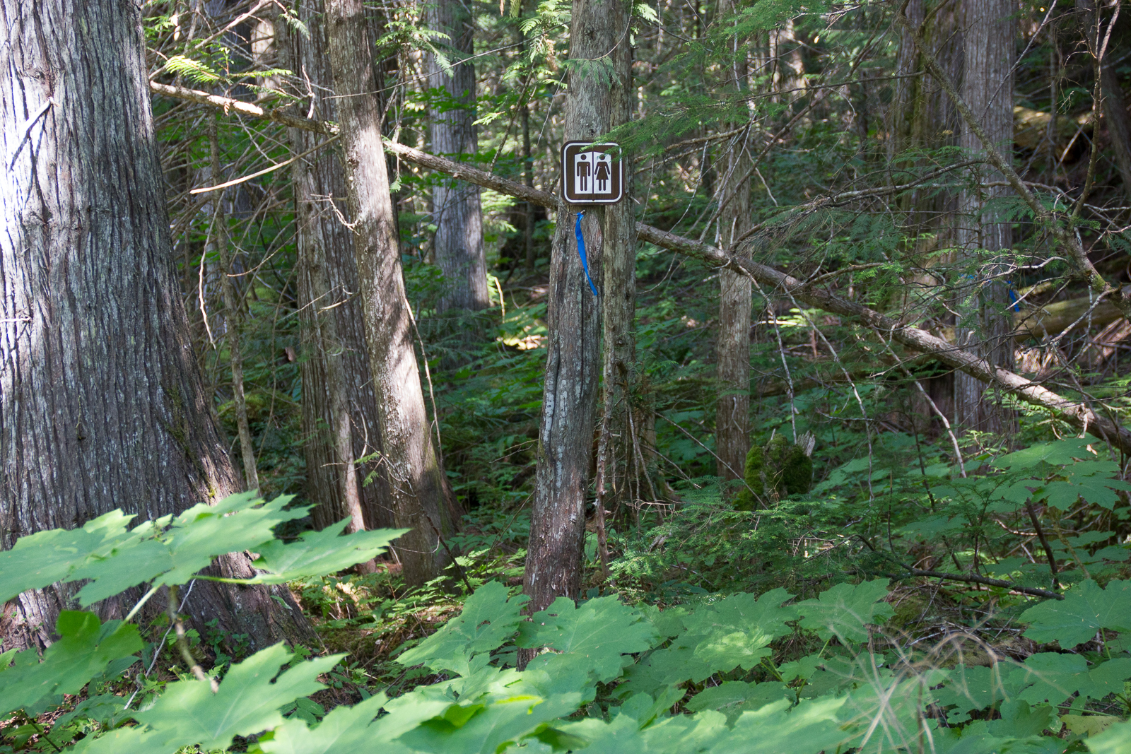
We spent our first night near the Garnet Beach campsite after we had made about 6 kilometers. It was already late in the day and we didn’t know how much longer it would take us to reach the wilderness campsite. “Campsite” just means that it’s a designated place where there’s enough flat ground to pitch a tent and that you should use in order to minimize the impact on plants and nature. There’s usually just a small sign nailed to a tree telling you that you’ve reached the place and nothing like toilets or picnic tables.
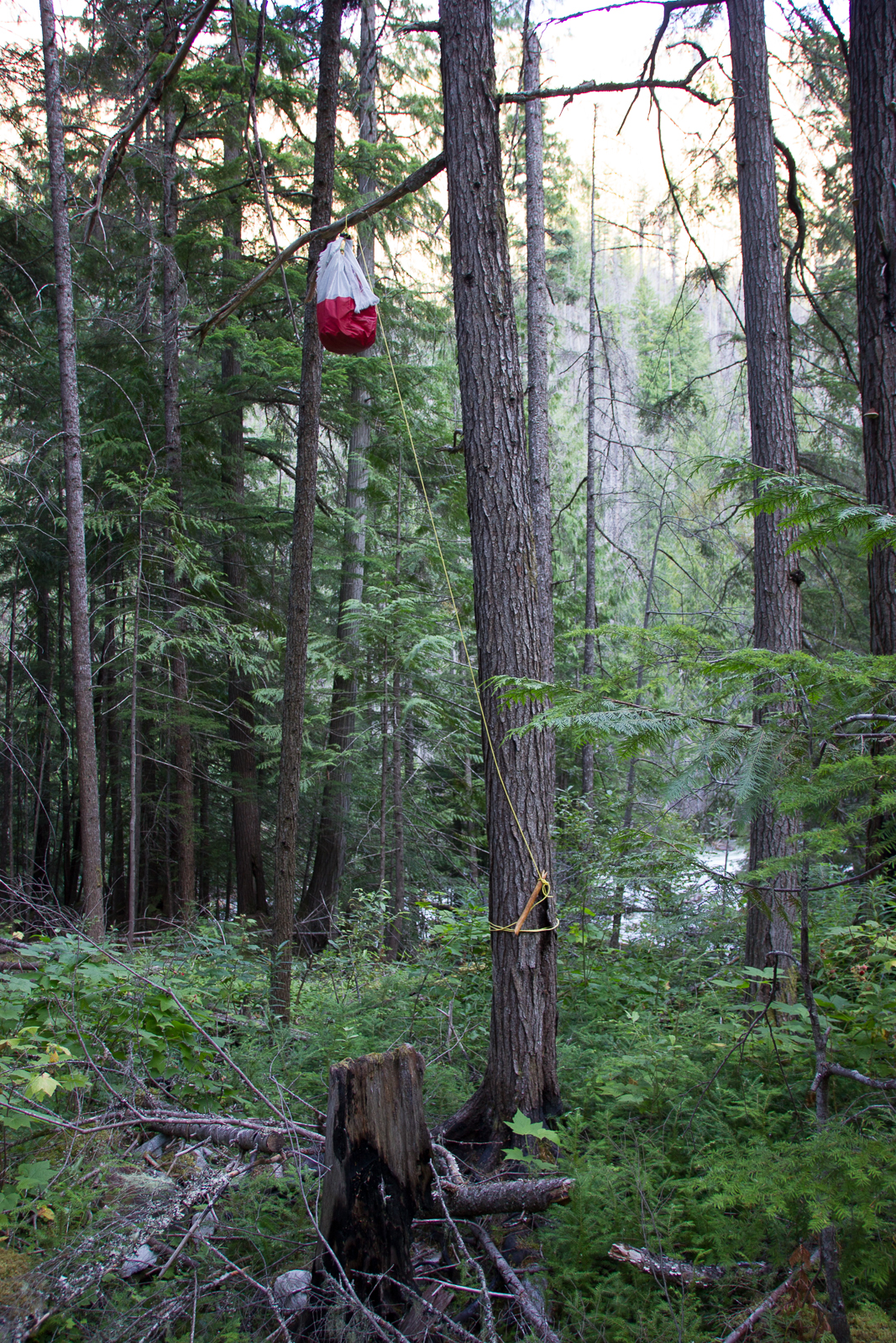
While we made our way along the trail we saw lots of tracks and other traces of black bears. We had known in advance that there are grizzlys and black bears in the Purcell wilderness so we tried to stick to the recommended safety measures. That means that we carried bear spray with us (pepper spray), cooked our dinners at least 50 meters downwind from our tent and put eveything that has a distinct odor (like food, soap etc.) in a bag and up a tree over night. In the areas where there was a lot of shrub we also used our bear bells to announce our presence and not startle a bear. We were a bit disappointed that we didn’t get to see any bears though and in general we only saw small animals during our hike. It’s kind of funny that the larger specimens of wildlife can often be seen at the side of the road from your car (especially in national parks) and you get to see next to nothing in the really wild areas. Of course the animals there are not used to encounters with people and are much more shy.
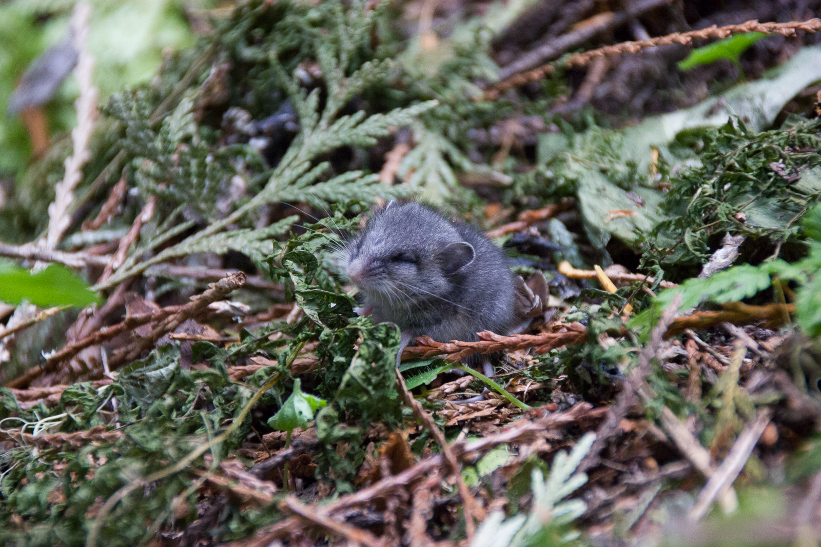
There was one noticeable encounter at least – at one point Martin suddenly froze with one foot in mid-air since he had nearly crushed some sort of tiny mouse. The little rodent sat huddled on the ground, had it’s eyes closed and tried to get our smell by sniffing around with it’s tiny nose. We thought that it might have been a newborn animal that maybe had wandered out of the nest and gotten separated from it’s mother. We found it difficult to just leave it there and head on but we thought that the mother might hopefully be able to find it again and take it to safety.
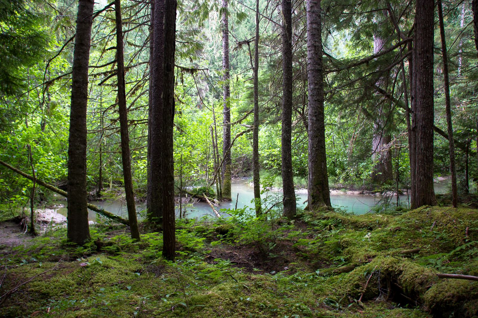
We didn’t spend our second night at one of the wilderness campsites either but in the middle of a fairy-tale forest somewhere behind the Big Bar campsite since we hadn’t gotten as far as we wanted. The whoe forest was covered by soft and bright green moss everywhere. The trail led up a small hill there so a small stream from Crazy Creek gurgled through the woods down to the Hamill Creek river. Once it has reached the river it turns to the same milky blue colour like the rest of the water there.


That night we decided to turn around the next day and start the way back. The rain was one of the factors but mainly we just wanted to be out in nature for a few days and not put pressure on us to make a certain distance. So we turned around shortly before the third cable car and finally managed to use the wilderness campsites on our way back. The first one was (for the third night of four in total) the Big Bar campsite that was situated very nicely right at the river.
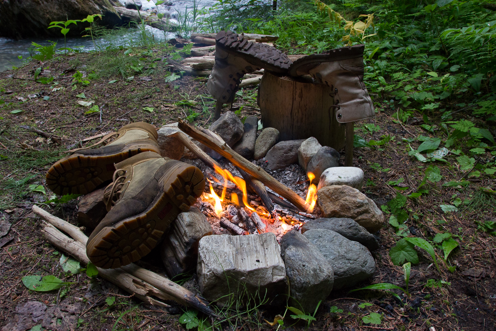
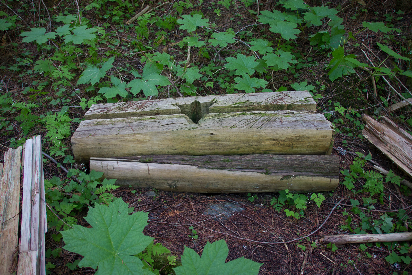
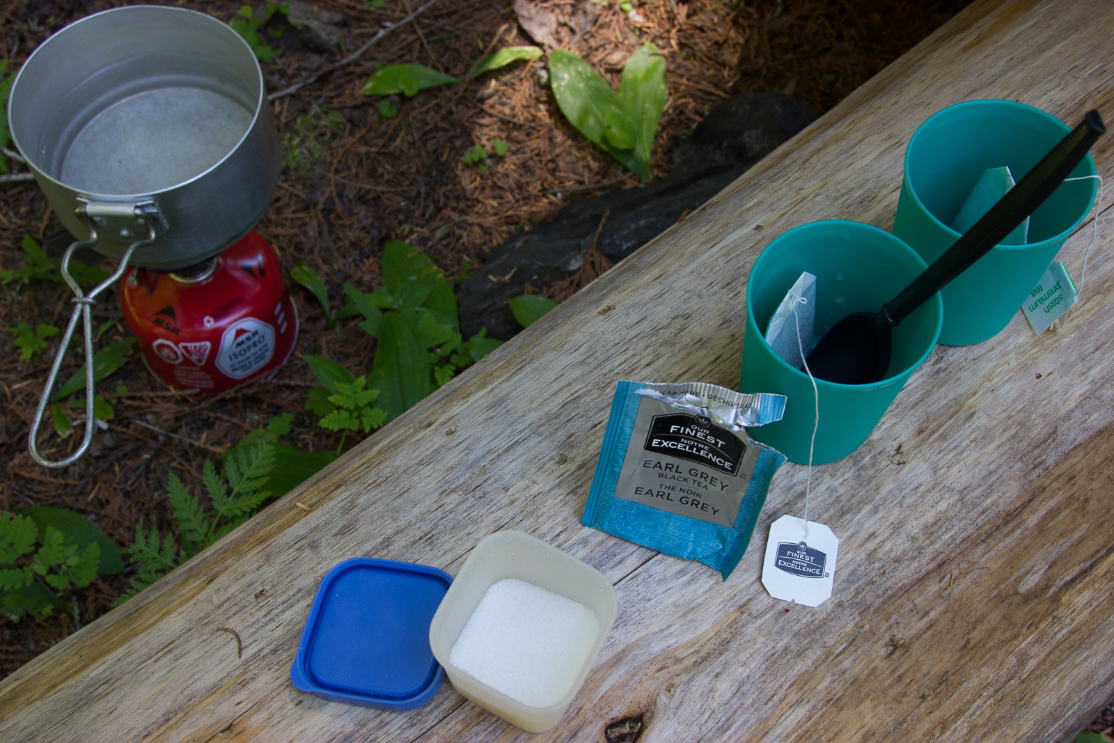
We arrived there alreay at the early afternoon and were happy to be able to dry our soaked shoes at last. The weather had turned out nice for a change and I took one of our sleeping pads and relaxed in the sun. We built ourselves a nice campfire, had some Earl Grey tea and admired the ingeniuos construction of the open-air pit toilet in the designated toilet area.
The fourth and last night we spent at the very first campsite right at the bottom of a steep incline. We remembered a pretty steep and long descent at the western trailhead so we thought it might be easiest to only leave this part of the trail for our last day of hiking. Before we got there we had to cross the river two times in cable cars again and also went past an old mining site and a ruined log cabin. At that pint we looked like veritable outdoors people with our dirty and torn clothes and coverved in insect bites, scratches, thorns and splinters. After we had washed ourselves in the freezing cold river every day we were also looking forward to the hot shower awaiting us at our camper.
The final ascent at the fifth day of our hike turned out to be way shorter and less demanding than we remembered and after not even an hour we had made it. We weren’t sorry to have stayed out one night longer than absolutely necessary though. It way very nice to go hiking without any pressure to reach a certain goal in a predefined amount of time and all in all we had also been lucky regarding the weather. We can strongly recommend the Earl Greay Pass Trail to everyone who is looking for a hiking experience close to nature and without the usual infrastructure. We were also happy that there was practically no trash to be found lying around along the trail and we hope that the Purcell Wilderness will continue to be treated with respect by it’s visitors and also stays an adventure you can get for free. The trail doesn’t get used very often so you almost have to be “unlucky” to meet other hikers while on one’s way. For a few days we felt like we were all alone with nature and that is an experience not a lot of hiking trails can provide.


German version – deutsche Version
Die grobe Route durch Kanada war klar: Wir wollten die Nationalparks Banff und Jasper sehen und anschließend nach Edmonton um einen weiteren Teil meiner Verwandtschaft zu besuchen. Auf unserer Suche nach mehrtägigen Wanderungen kam aber noch eine ganz neue, unbekannte Region ins Spiel: der Purcell Wilderness Conservancy Provincial Park ein kleines Stück westlich von Banff, kurz: die Purcell Wildnis, benannt nach den gleichnamigem Gebirge, das zwischen den Ost- und West-Kootenays (ein weiterer, größerer Gebirgszug) verläuft.
Vorher ergab sich aber noch eine kleine Stippvisite bei Rita und ihrem Mann Kevin. Rita ist Alfreds Schwester, also ebenso meine Halbcousine, und wohnt in Kamloops, einer Wüstenstadt direkt am Trans-Kanada-Highway. Alfred hatte uns ihre Telefonnummer gegeben, für den Fall, dass wir bei ihr vorbeikämen und so kam es dann auch. Wir verbrachten sogar ganze drei Tage in Kamloops, da es die einzige richtige Stadt zwischen Vancouver und der Purcell Wildnis entlang des Trans-Kanada-Highways ist. Als ich Rita anrief, war ich natürlich (mal wieder) mächtig aufgeregt und war erleichtert, dass sie von Alfred vorgewarnt wurde. Sie kam am Telefon direkt sehr nett rüber und es war denkbar unkompliziert, ein Treffen mit ihr zu vereinbaren: Drei Stunden nach dem Anruf saßen Martin und ich bei ihr im Wohnzimmer. Es stellte sich heraus, dass sie und ihr Mann die Sonne liebten und den Sommer in Kamloops und den Winter in Arizona verbrachten, wo wir ja unsere USA-Reise begonnen hatten und tatsächlich war uns aufgefallen, dass Kamloops große Ähnlichkeiten zu Phoenix und Umgebung hat. Wir blieben drei Stunden, erzählten von unserer Reise und hörten Geschichten aus dem Erfahrungsschatz unserer Gastgeber, die mit ihrem Wohnwagen auch viel erleben. Der Abschied war herzlich und wir waren froh die beiden besucht zu haben. Wir wünschen ihnen noch viele großartige Reisen mit ihrem Trailer!
Die Stadt Kamloops an sich hatte uns nicht viel zu bieten: Das Wetter war Hitze pur, für uns kein Thema, wir waren froh drum. Aber ein Großteil der Stadt besteht aus einer Ansammlung von Malls und Fast-Food-Ketten, wie wir es schon von vielen Städten in den USA kennengelernt hatten. Zu unserer Überraschung fanden wir aber nur wenige Kilometer von Kamloops entfernt einen tollen Übernachtungsplatz: Den Greenstone Mountain Provincial Park. Der hauptsächlich von ATV-Fahrern frequentierte Park ist so weitläufig, dass an jeder Ecke ein nettes Plätzchen zu finden ist, wo man seine Ruhe hat. Im Totholz wimmelte es nur so von Streifenhörnchen und kurz nach unserer Ankunft sahen wir doch tatsächlich einen Wolf! Es war später Nachmittag und wir sahen ihn in vielleicht 200 Meter Entfernung im Profil, wie er einen Hügel hinauflief. Die vielen ATV-Wege um unseren Stellplatz herum wurden zum Glück nicht benutzt. Wie gesagt, der Park war so groß, dass man sich prima aus dem Weg gehen konnte. Man hörte zwar ab und an Motorengeräusche aber für einen Gratis-Übernachtungsplatz war Greenstone erfreulich wild.
Wir bleiben zwei Nächte im Wald und machten tagsüber Besorgungen für die anstehende Wanderung. Zudem war eine Fahrzeuginspektion fällig, die zu unserer Erleichterung ergab, dass mit unserem Ford alles in Butter ist.
Weiter Richtung Purcell machten wir erneut Zwischenstopp in einer Stadt namens Revelstoke. Und wow, was für ein Trubel uns dort erwartete! Die Stadt war voll mit Touristen – proppenvoll! Ein Camper neben dem anderen, vom kleinen VW Bus (sehr beliebt in Kanada, vor allem das Westfalia Model) bis zu Mega-Campmobilen, die von LKWs gezogen wurden (was nicht wirklich nötig ist … Sprit ist eben auch in Kanada noch zu billig). Dennoch: Revelstoke ist ein nettes Städtchen und wir erwarben dort eines unserer praktischsten Ausrüstungsstücke, nämlich den LifeStraw. Es handelt sich dabei um einen handlichen Wasserfilter, der einem erlaubt, praktisch aus jedem Gewässer Trinkwasser zu gewinnen und zwar einfach nur, indem man den LifeStraw wie einem Trinkhalm benutzt. Kurioserweise hatten wir im Bill & Melinda Gates Museum in Seattle davon gehört, da die Stiftung diese Erfindung finanziell gefördert hatte (eigentlicher Zweck: Sauberes Wasser für Menschen, die keinen Zugang zu Trinkwasser haben oder in Katastrophengebieten). Mit gerade einmal 30 Euro war der LifeStraw eine lohnende Sache für uns, würde er uns doch ersparen, Liter von Wasser mit uns rumzuschleppen und uns stattdessen erlauben, Flusswasser zu trinken (schlimm genug, dass man das heute selbst in Schutzgebieten nur noch mit Filter tun kann!).
Revelstoke war unser Ausgangspunkt um die Fähre zu erreichen, die wir nehmen mussten, um den Westteil des Purcell Wilderness Conservancy Provincial Parks und damit unseren Wanderweg, den Earl Grey Trail, zu erreichen. Dieser 61 Kilometer lange Wanderweg quer durch die Purcell Wildnis wurde nach eben diesem “Mister Tea” benannt, der dort einen alten Minen-Weg wiederentdeckt hatte (Earl Grey war Anfang des 20. Jahrhunderts der General-Gouverneur von Kanada.). Wir hatten nicht vor die ganzen 61 Kilometer zu laufen, da es sich hier nicht um einen Rundweg handelt und wir arge Schwierigkeiten gehabt hätten, vom Ostende des Weges wieder zurück zu unserem Auto zu kommen (es sind mehr als 400 km Fahrt). Wir packten stattdessen Proviant für fünf Tage ein und ließen auf uns zukommen, an welchem Punkt der Route wir wieder umkehren müssten.
Es ist reichlich aufwendig, an das Westende des Earl Grey Trails zu gelangen. Zunächst fährt man von Revelstoke aus gute 50 Kilometer durch die Pampa, wo eine Fähre über den Upper Arrow Lake wartet. Die 15-20 minütige Überfahrt ist kostenfrei und das obwohl die Fähre pausenlos hin- und her fährt. Danach folgen gute 100 Kilometer Schotterpiste durch eine wunderschöne abgelegene Gegend bis hin zu dem winzigen Nest namens Argenta. Argenta soll laut Karte ein Ort sein; in der Praxis handelt es sich hier um einen sehr losen Verbund von ein paar Holzhäuschen und einer Poststation. Wer hier lebt, tut es aus Überzeugung. Im Winter ist es sicherlich nicht witzig, aber im Sommer: Ein Traum!
Kurz bevor wir (nach dreistündiger Fahrt) den Beginn des Earl Grey Wanderwegs erreichten, passierten wir eine etwas unheimliche Ansammlung alter, teils ausgeschlachteter Autos. Bei manchen standen die Türen offen, als habe irgendein verrückter Hillbilly gerade erst die letzten Wanderer aus dem Wrack gezogen. Auch ein Schild mit der Aufschrift “Sunshine” (Sonnenschein) kann diesen Eindruck nicht lindern.
Direkt nach dem Auto-Friedhof parkten wir unseren Camper und schliefen dort eine Nacht, um am nächsten Morgen früh aufbrechen zu können. Bis wir alles beisammen hatten, dauerte es dennoch seine Zeit und es war bereits früher Mittag, als wir endlich am Beginn des Wanderweges ankamen. Wir trugen uns im Gästebuch ein und stellten fest, dass wir nicht die Einzigen auf diesem abgelegenem Pfad waren. Ein Vater mit Sohn hatten den Weg kurz vor uns angetreten (wir trafen sie drei Tage später auf dem Rückweg).
Es gibt im Internet nicht allzu viele Informationen zum Earl Grey Trail, weswegen wir in diesem Artikel ein paar Details zeigen wollen, die vielleicht für andere Wanderer interessant sind. Vorweg: Wir hatten gehofft es bis zum Earl Grey Pass zu schaffen, stellten aber schnell fest, dass wir mit einer Geschwindkeit von oft gerade einmal 1 km/h nie und nimmer so weit kommen würden und schafften es letztlich nur bis kurz vor die dritte Seilbahn was circa 26 Kilometern entspricht (Hin- und Zurück). Grund für das langsame Fortkommen ist der teils kaum ausgebaute Wanderpfad. Es gibt viele umgestürzte Bäume, über die geklettert werden muss und lange Teile der Strecke bestehen aus wildwucherndem Gestrüpp, was wir erst mit der Machete aus dem Weg räumen mussten. Die Seilbahnen, die unverzichtbar für einige Überquerungen des tosenden Flusses sind, sind schwer zu bedienen. Zumindest war das der Fall, als wir sie benutzten. Martin kam klar, aber ich hatte große Schwierigkeiten die Kabinen überhaupt zu bewegen.
Die erste Nacht verbrachten wir nach circa 6 Kilometern nahe Garnet Beach, weil es bereits spät am Tage war und wir nicht abschätzen konnten, wie lange wir noch zum Campingplatz brauchen würden. Campingplatz heißt übrigens nicht, dass es hier irgendeine Art von Einrichtung wie Toiletten oder Tische oder gar gekennzeichnete Plätze gäbe. Die Campingplätze in der Purcell Wildnis sind einfach nur durch ein Schild gekennzeichnete, zum Zelten geeignete Plätze, die genutzt werden sollen, um den Rest des Parks vor menschlichen Einflüssen zu schützen.
Im Laufe der Wanderung trafen wir andauernd auf Spuren von Schwarzbären. Wir waren vorgewarnt, dass es in der Purcell Wildnis Schwarzbären und Grizzlys gibt und waren bemüht die Sicherheitsvorkehrungen einzuhalten; das heißt wir hatten Bärenspray (Pfeffer-Spray) dabei, kochten fern vom Zelt und sicherten alle Dinge, die geruchsintensiv sind (wie Nahrung und Seife) weit oben im Baum. In zugewucherten Gebieten packten wir außerdem unsere Bärenglöckchen aus um unser Kommen anzukündigen und keinen Bären zu erschrecken. Leider kam es zu keiner Begegnung mit einem Bären und auch sonst beschränkten sich unsere Tierbegegnungen mehr auf kleines Getier. Es ist schon kurios, dass die meisten großen Tiere aus dem Auto heraus am Straßenrand zu sehen sind (vor allem in Nationalparks) und man in den wirklich “wilden” Gebieten viel seltener etwas zu Gesicht bekommt. Klar, hier sind die Tiere einfach nicht an Menschen gewöhnt und halten sich fern.
Einen besonderen Umstand gab es jedoch: Martin verharrte plötzlich mit seinem Fuß wenige Zentimeter über dem Boden, weil er um Haaresbreite eine Art winzige Maus zertreten hätte. Der kleine Nager saß zusammengekauert auf dem Boden, die Augen noch geschlossen, und schnupperte mit dem kleinen Näschen in unsere Richtung. Wir interpretierten, dass es ein Neugeborenes sein musste, was aus irgendeinem Grund von Nest und Mutter getrennt worden war. So schwer es auch fiel, wir liefen weiter in der Hoffnung, dass die Mutter ihr Junges finden und wieder zurückholen würde.
Die zweite Nacht verbrachten wir ebenfalls nicht auf einem Campingplatz, sondern inmitten eines märchenhaften Waldes hinter dem Campingplatz Big Bar, weil wir nicht genug Strecke zurückgelegt hatten. Das Waldgebiet, von dem ich spreche, ist am Boden von dichtem, hellgrünem, weichem Moos bewachsen. Der Wanderweg führt durch eine Hanglage, so dass ein Wasserlauf von den höheren Waldgebieten nach unten zum Fluß im Hamill Creek plätschert. Im Tal angekommen nimmt das Wasser eine milchig-blaue Farbe an.
Am Abend beschlossen wir, bereits am nächsten Morgen umzukehren. Der Regen war Teil der Entscheidung, aber in erster Linie wollten wir unser Pensum stressfrei schaffen. Wir kehrten also kurz vor der dritten Seilbahn um und schafften es diesmal auch, die offiziellen Campingplätze zu nutzen. Zunächst war dies – für die dritte von vier Nächten – der Big Bar Campingplatz mit einer schönen Lage direkt am Fluß.
Wir kamen bereits am frühen Vormittag dort an und waren froh, endlich unsere durchnässten Schuhe ablegen zu können. Das Wetter war uns wieder wohlgesonnen und ich flätzte mich auf eine der Isomatten in die Sonne. Wir machten Lagerfeuer, tranken Earl Grey Tee und bewunderten das einfallsreiche Plumpsklo in der beschilderten Kloecke.
Die vierte und letzte Nacht verbrachten wir auf dem allerersten Campingplatz direkt vor dem Aufstieg. Wir hatten den Abstieg als sehr lang und steil in Erinnerung und dachten, dass es am bequemsten wäre sich den fünften Tag einzig und allein für den Aufstieg aufzubewahren. Vorher mussten aber noch mal die erste und zweite Flußüberquerung gemeistert werden und wir passierten abermals eine alte Minenstätte und ein verlassenes Blockhaus. Mittlerweile sahen wir aus wie echte Waldmenschen mit verdreckten und zerrissenen Klamotten und voller Kratzer, Dornen und Splitter, sowie Mückenstichen. Nach dem täglichen Waschen im eiskalten Fluss freuten wir uns außerdem auf die heiße Dusche, die uns am Camper erwartete.
Der Aufstieg am fünften Tag unserer Wanderung entpuppte sich als nicht einmal einstündiges nicht allzu anstrengendes Vergnügen, doch wir bereuten nicht, eine Nacht extra draußen verbracht zu haben. Es war schön ohne Zeitdruck wandern gehen zu können und letztlich hatten wir auch mit dem Wetter Glück. Wir können den Earl Grey Trail jedenfalls wärmstens an alle weiterempfehlen, die ein möglichst naturnahes Erlebnis suchen und keinen Wert auf einen ausgebauten Wanderweg legen. Wir waren auch sehr glücklich darüber, quasi keinen Müll auf der ganzen Strecke gefunden zu haben und hoffen, dass die Purcell Wildness auch weiterhin mit Respekt behandelt wird und ein kostenloses Vergnügen bleibt. Der Trail wird zudem nicht sehr häufig benutzt und man muss beinahe “Pech” haben um unterwegs andere Wanderer zu treffen. Wir fühlten uns für einige Tage als wären wir ganz allein mit der Natur und das können einem nur wenige Wanderwege bieten.